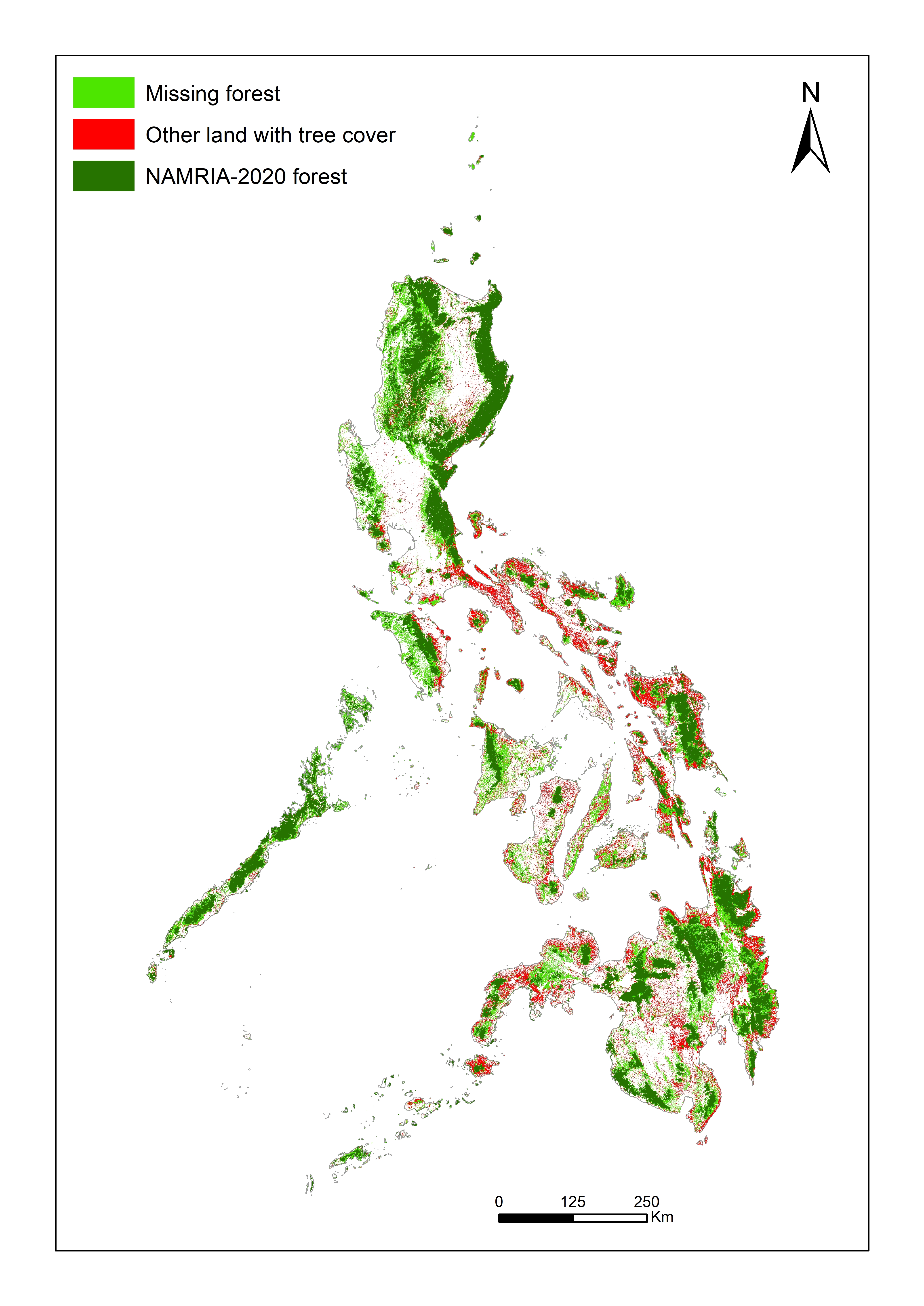
This dataset contains maps of forests and other land with tree cover in the Philippines as of the year 2020. The data can be downloaded directly here: https://drive.google.com/drive/folders/1dPdRbmPjTRJKtOuOa5s2lMXvIEcfhw-… The dataset contains three georeferenced maps: (1) A map of lands identified as "Open forest", "Closed forest", or...
- Clear all
- Type: (-) Data or Tool
- Topic: (-) Forests
- Topic: (-) Resource Efficiency and Circular Economy
Results 1 - 10 of 13 (Sorted by date)
IGES Centre Collaborating with UNEP on Environmental Technologies (CCET) has developed version III of the IGES-GHG calculator entitled "Estimation Tool for Greenhouse Gas (GHG) Emissions from Municipal Solid Waste (MSW) Management in a Life Cycle Perspective", a tool that enables to estimate GHG emissions from the waste sector in China in the Life...
Ecology Note – Towards Clean and Beautiful Capital City – is a supplementary material for primary school teachers who wish to introduce environmental education for the first time, or for those who want to enhance the scope of educational work in addition to what is already taught in the classrooms. The scope of environmental education is wide...
Editor:
This voluntary standard is based on participatory research with forest sector parties to develop methods for evaluating the governance quality of forest sector programmes and projects, including emissions reduction activities, in Nepal. The research was conducted July 2011 – January 2016 by Dr Federico Lopez-Casero of the Institute for Global...
In 2011, IGES-Sustainable Consumption and Production (SCP) Group, in collaboration with local counterparts, conducted capacity building workshops for local governments to promote waste utilisation for climate change mitigation in Cambodia, Lao PDR and Thailand. Also, there was training on estimations of GHG emissions from waste management practices...
UCI Machine Learning Repository
This data set (http://archive.ics.uci.edu/ml/datasets/Forest+type+mapping) contains training and testing data from a remote sensing study which mapped different forest types based on their spectral characteristics at visible-to-near infrared wavelengths, using ASTER satellite imagery. The data set be used to evaluate the performance of different...
IGES Remote Sensing Toolbox
This is an ArcGIS 10.x toolbox that includes Geographic Information Systems (GIS) tools for vegetation analysis (creating Vegetation Indices and Fractional Vegetation Cover maps) and image pansharpening. It can be used for processing and analysis of Landsat 8 or other satellite imagery. The toolbox is designed for GIS and Remote Sensing...